This year we took along three friends who had never been there before. Happily, recent rains kept the usually dusty logging roads nearly dust free and recent road work had wiped out the formerly monstrous potholes that made the last miles of the trip a nightmare. Our first stop was near a bridge where a break in the trees gave a view of a distant hillside with big trees and snags. There we located a former Bald Eagle nest, which made one of our crew, eagle monitor Michael, very happy. But it had not been used in a long time, probably because Valsetz lake and its fish no longer exist, the dam having been removed in the 80s. Here our happy crew is returning from a hike to look for another eagle nest, but that one had apparently disintegrated, or gone down in a wind storm with its tree.
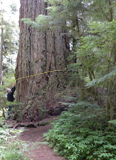
Michael brought along his tape and soon he and Johnny were measuring trees along the VOG trail. The biggest they measured was the first one, at about 30 feet in circumference or 9.5 feet in diameter... at least where they measured it. The others ranged from 23 to 28.5 feet (7.5 to 9 feet diameter). Big trees.
But "Big Guy", the second tallest tree in Oregon when standing, is now on the ground. According to Wikipedia, "Before 'Big Guy' was blown down by a wind storm in 1981, it was estimated to be over 600 years old, stood approximately 230 feet (70 m) above the forest floor, and had an estimated 36.5-foot (11.1 m) girth."
Carol slithers through the gap between two sections of the giant tree.
And here she models in the middle of a grove of the big trees.
But Valley of the Giants is not just big trees. A beautiful stream flows through with a busy Dipper and a lovely bridge going over. The crew... Brian, Carol, Michael and Johnny... enjoy the view from either side.
Michael and Brian both had Garmin GPS units and spent much of the day watching our progress on their little screens. Boys must have toys. Carol and I had a good laugh when we came to a fork in the VOG trail and were not sure which way led back to the van. Brian's Garmin pointed one direction and Michael's another. We followed Garmin-less Johnny. He was right.
Since our mission this day was to scout the BBS route, after hiking the VOG trail we drove to our camping place and hiked in to my first stop... using clippers and an axe to help clear the way a bit. Hiking in the morning before daylight, as we must do on our BBS day, is a bit treacherous through all that brush and downed trees. Then we drove out, checking the rest of our 50 stops, each 1/2 mile apart, to make sure they were marked with mileage signs or other landmarks.
At the last stop, Johnny and I were surprised at how much taller the trees were than last year. This was a good year for growth. Michael stands atop the stump I used to be able to scan the former clearcut from, probably checking his Garmin to see where he is.
Carol found a higher viewpoint on the van.
And then we headed back to Dallas, dinner at the Ixtapa Mexican restaurant, and our respective homes.
Now all Johnny and I have to do is run the actual BBS... on another Sunday when the logging trucks are not on the road. Hopefully, it will be as lovely as today.


The drive doesn't sound at all appealing, but wow, what great trees and views -- I love the bridge!
ReplyDeleteYour viewpoint mirrors how our guests felt, I'm sure. But that drive is way more appealing than it used to be now that they've graded the roads. However, they grade for logging traffic so Sunday, when the log trucks don't roll, is for sure the only safe day to travel.
Delete