Friday, October 18, 2013
Exploring A Coast Range Triangle
Along with all the winterizing and catching-up projects we are doing during this spectacular fall weather, we have also been enjoying the sunny warm days throughout a triangle that starts from our farm on the east, goes southwest to Lincoln City and northwest to Cape Lookout.
Inside that triangle is Mt. Hebo. We took a Sunday drive to Mt. Hebo by way of Hebo Rd. and Gunaldo Falls. I have long wanted to hike to the bottom of that difficult-to-see waterfall and so we did. My photos did not come out great. This horsetail falls has two drops, the top one is five feet, the bottom 35 feet. But seeing the falls through the trees is difficult.
Although it is very close to Hebo Rd., getting there is treacherous... mostly because of years of accumulated trash that people have thrown down the hillside, now trapped between trees and salmon berries and salal and downfalls on the steep drop into Sourgrass Creek. I waded across the creek while Johnny walked a narrow log across, then clambered up alongside the unnamed stream to the base of the falls.
From the bottom of the falls we could not see the top drop. Someday I want to hike to the top of the falls.
But that day we drove on to Mt. Hebo. This is the first time we have been up there in sunshine and no wind. And the first time I realized how far you can see from up there. We could see nearly that whole triangle of territory that includes my Black Oystercatcher sites... and beyond.
Looking north... Tillamook.
And Oceanside...
My camera zoomed up the rocks off Oceanside...
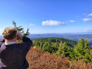
The next cape south is Cape Lookout. Johnny is peering at it way off in the distance.
My camera brought it closer.
Later in the week, a friend and I hiked the Cape Lookout area searching for a viewpoint to scope the offshore rocks on the north side. That tale later...
Farther south was Cape Kiwanda, a much smaller cape than its northern neighbors.
Off Cape Kiwanda is Haystack Rock where we found two Black Oystercatcher families a few days after our Mt. Hebo trek. That story also a little later... Here is that view of the Pacific City and Cape Kiwanda area brought up closer. Can you see the little spot beyond the cliff that is Haystack Rock?
And here my wonderful camera brought it into view.
Cascade Head was a bit too far south and blocked by mountain ridges, as was our Road's End Black Oystercatcher territory. We hiked that area the same day we did Cape Kiwanda and will also tell that tale next time.
We left the Hebo radar station then and took Forest Service road 1400 back home.
Along the way we stopped at North Lake, which appeared to be full of algae but turned out to be water cress.
A pair of Hooded Mergansers were pushing their way through the green pond.
We must have seen a hundred Varied Thrushes on our journey. This photo was taken through the windshield.
Next time, I'll tell the Cape Kiwanda and Cape Lookout stories from this past week, along with stories from the point of the triangle from which our journeys originate: the farm.
Subscribe to:
Post Comments (Atom)


No comments:
Post a Comment